The 'El Niño' phenomenon is now in its active phase. Sea surface temperatures in the central and tropical Pacific have already exceeded the 0.5 °C above-average threshold established to define an 'El Niño' event.
In addition, winds over the equatorial Pacific have begun to shift direction, carrying warm waters toward South America, indicating that the atmosphere is responding to the warming of the ocean. When this occurs, the presence of 'El Niño' is officially confirmed.
1. Why is there talk of a 'Super El Niño' this year?
For the 'El Niño' phenomenon to be officially declared, the temperature of the Pacific Ocean need only rise 0.5°C above the historical average. For 2026, forecasts indicate a 63% probability of a strong El Niño, meaning that sea surface temperatures in the Pacific region will exceed 2.0 °C.
It is these expected values that have led to terms such as 'Super El Niño' being used to describe a strong 'El Niño ', as was the case in 2015 with 'Godzilla El Niño'. The transition from cooling conditions (La Niña) to extreme warming has been much faster than usual, forcing humanitarian organizations such as the IFRC to scale up their preparedness levels immediately.
2. What impact will 'El Niño' have on Central America and the Caribbean?
'El Niño' does not affect the entire continent in the same way. One of the greatest concerns in the north is the reduction in rainfall. In Central America and the Caribbean, 'El Niño' typically manifests as a significant reduction in cumulative rainfall. This does not mean there is no rain at all, but rather that the pattern of precipitation is irregular and insufficient to sustain traditional agricultural cycles.
The Central American Dry Corridor is one of the regions where the impact is particularly severe, with prolonged water deficits directly threatening food security and the livelihoods of thousands of families. Water scarcity affects not only crops but also increases public health risks related to access to safe water and hygiene.
3. What effects are expected from 'El Niño' in South America?
Unlike in the north, 'El Niño' has the opposite effect in the southern part of the continent. While countries such as Colombia, Venezuela and northern Brazil face drier conditions and an increased risk of wildfires, regions in southern Brazil, Uruguay, northern Argentina and central Chile must prepare for above-average rainfall.
This geographical contrast within the same continent means that the Red Cross and its partners must implement different strategies.
4. What is the forecast for the hurricane season under the 'El Niño' 2026?
Historically, there has been a direct correlation between the presence of a strong 'El Niño' phenomenon and a decrease in the frequency and intensity of tropical cyclones in the Atlantic basin. In the Pacific, where hurricanes also occur, rising sea temperatures combined with changes in wind patterns caused by 'El Niño' can create conditions that are more favorable for storm formation.
Forecasts indicate that the Atlantic will see below-average cyclonic activity, with fewer than the historical average of 14 named storms and seven hurricanes.
Meanwhile, forecasts for the Pacific predict between 15 and 22 named storms, of which between nine and 14 are expected to become hurricanes, and between five and nine of those are expected to become major hurricanes.
Regardless of the forecast, evidence shows that one single tropical storm forming and making landfall can devastate entire communities. Decades of working with communities at risk from hurricanes have taught the Red Cross that the most efficient, effective and ethical approach is to invest in preparedness and early response initiatives to protect communities and their livelihoods.
5. How do we prepare for the impacts of 'El Niño'?
The Red Cross network's main strategy for addressing this phenomenon is anticipatory action, which refers to any action taken before a crisis occurs with the aim of preventing or reducing the potential impacts of a disaster.
The Climate Centre collaborates with National Societies to update Early Action Protocols, enabling the immediate release of emergency funding when specific scientific thresholds are met.
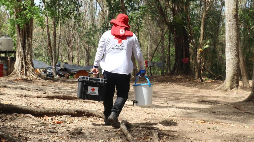
Three Early Action Protocols have already been activated in the Americas region. Red Cross teams in El Salvador, Guatemala and Colombia developed their protocols to protect over 22,000 people at the first signs of drought.
The Disaster Response Emergency Fund (IFRC-DREF) has allocated 1.2 million Swiss francs (CHF)—about 1.5 million U.S. dollars—for early action in response to the drought in the three countries. This funding is not allocated all at once: it is released in stages as forecasts reach risk thresholds agreed upon in advance by communities, authorities, and the Red Cross, so that each tranche of aid is mobilized just before the impact and not after.
These funds will provide assistance to 10,000 people in the El Salvadoran departments of Morazán and La Unión; 10,000 more in Guatemalan municipalities in the Dry Corridor, such as Chiquimula, Jalapa, and Quetzaltenango; and 2,400 in Colombia's Tolima and Cesar departments.
The Red Cross will support the most vulnerable families by providing them with cash to purchase food, fuel, and other necessities, helping them to avoid depleting their own resources. The Red Cross will also provide drinking water when sources begin to run low, supplies to care for crops and livestock, and training in adaptive agricultural practices, hygiene, and the prevention of heat-related illness.
For countries that do not yet have these formal protocols, the IFRC network offers technical assistance tools and access to the Disaster Response Emergency Fund (IFRC-DREF for imminent events.
The aim is to anticipate risks, strengthen preparedness and use scientific evidence to protect households, ensure effective humanitarian assistance and safeguard community health before the effects of 'El Niño' peak.
Where can I find more information?
- Our Early Warning, Early Action page