
The 2025 Atlantic hurricane season is still active in the Americas. Meteorologists, disaster management experts and public authorities are keeping a close eye on hurricane Melissa, the 13th storm of the year, which is currently moving slowly towards Jamaica.
Out of the 19 storms forecast this year, 13 have formed. Four of those became hurricanes categorised as either 1 or 2. Three of these reached major hurricane status, meaning Category 3 or higher.
But how much do we really know about how storms and hurricanes form, their characteristics, and how to prepare for them? Below, we answer five of the most common questions about storms and hurricanes.️
️1. What is the difference between a tropical storm and a hurricane?
Both are part of the same system: the tropical cyclone. This is defined as a low-pressure system that rotates counterclockwise in the northern hemisphere and clockwise in the southern hemisphere.
The intensity varies. A tropical storm is characterized by winds of between 63 and 118 km/h, whereas a hurricane is characterized by winds exceeding 119 km/h.
These phenomena have different names depending on where they develop:
- Cyclones when they occur in the waters of Southeast Asia and the Indian Ocean.
- Typhoons occur in the waters of East Asia and the Pacific.
- Hurricanes occur in the Atlantic, the Gulf of Mexico or the Caribbean Sea.
Each type is associated with a season that can last up to seven months a year.
A major hurricane does not need to form in order to endanger people's lives. The rain and winds caused by a single storm can pose a threat to people's health and well-being, and even to their survival, particularly in communities where climate change, poverty, misinformation and previous disasters increase population vulnerability.
In 2024, storms were classified as the second most frequent type of disaster worldwide, recorded in the EM-DAT database, affecting 29.5 million people globally.
Due to a combination of geographic, climatic, political and socioeconomic factors, countries such as Haiti, Cuba, Venezuela, the Dominican Republic, Nicaragua, Honduras, Guatemala, the Bahamas and Antigua and Barbuda are particularly vulnerable in the Americas.
Countries affected by Hurricane Beryl in 2024, such as Barbados, Grenada, Jamaica, and Saint Vincent and the Grenadines, also entered the 2025 season while still recovering.
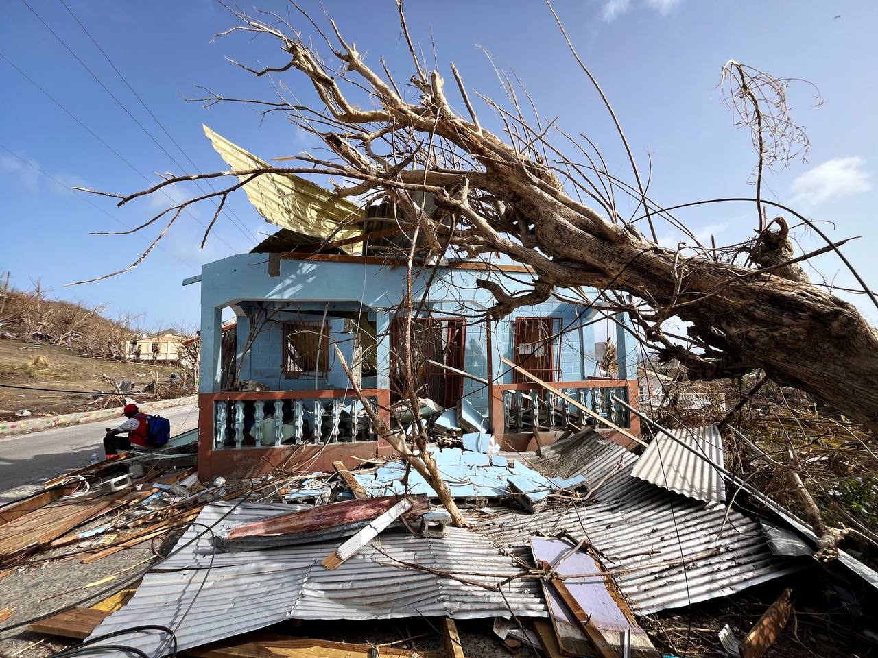
A massive tree has fallen over this home, one of thousands on the islands of Carriacou and Petite Martinique that were destoyed by Hurricane Beryl.
Photo: Susana Arroyo/IFRC
2. How do storms and hurricanes form?
They form over the sea. For this phenomenon to occur, the ocean water must be warm, with a temperature above 26°C. When warm, moist air rises, the vapour releases heat, strengthening the system and causing it to grow. If humidity and wind conditions are favourable, the system can grow into a hurricane.
An eye forms in the centre of the hurricane, creating an apparent calm. Meanwhile, dense clouds and intense winds form around it in an area known as the eyewall. The spiralling clouds release large amounts of water, which can cause flooding and landslides.
Hurricanes are driven by wind and follow paths that can vary depending on the direction and speed of currents at different levels of the atmosphere. When they make landfall, they lose the heat from the ocean — their source of energy — and begin to weaken.
We must pay close attention not only to the number of hurricanes forecast but also to how rapidly they intensify. Rapid intensification—defined as an increase in wind speed of 35 mph or more within 24 hours—has become more common due to warmer ocean temperatures fueled by climate change.
This sudden strengthening leaves little time for preparation, increasing the risk of catastrophic damage and loss of life. Notable examples include Hurricane Otis in 2023, which escalated from a tropical storm to a Category 5 hurricane in less than a day before striking Mexico's Pacific coast.
3. Why are storms and hurricanes named?
Names make it easy to identify each storm. Naming storms is the fastest way to issue alerts and prepare the population.
The World Meteorological Organization has lists of names that are reused every six years. These lists are arranged in alphabetical order, with male and female names taken in turns. If a hurricane causes significant destruction, its name is retired.
Names make it easier to track and analyze each storm, particularly when several are active at the same time. They also facilitate historical record-keeping and help avoid confusion among meteorological personnel, the media, emergency response agencies and the general public.
When compiling lists of names, certain factors are taken into consideration.
- They should be short.
- They should be easy to pronounce.
- They should have an appropriate meaning in different languages.
- They should be unique: the same names cannot be used in other regions.
4. How predictable are hurricanes?
Thanks to weather forecasts, we can anticipate the arrival of storms and hurricanes and prepare before disasters strike.
Technology enables us to track their path and speed across the sea with great accuracy. Hurricane Melissa, for example, is moving slowly, which means it poses a greater risk. The slower a storm or hurricane moves, the longer communities in its path will suffer strong winds and heavy rain. Rather than lasting a few hours, these conditions could persist for days, causing flooding or landslides.
This is why it is crucial for communities to complete their preparations before conditions deteriorate. It is important to combine forecasts with risk analysis to take early action in anticipation of hurricanes rather than simply responding to events as they happen.
The Red Cross, governments, communities and other humanitarian organisations can act before a disaster strikes by implementing early warning systems and evacuation protocols and carrying out drills, or by strategically placing humanitarian aid to ensure its rapid delivery to affected areas in the event of an emergency.
This approach enables us to anticipate disasters, minimise their impact, and prevent suffering, loss of life and loss of livelihoods.
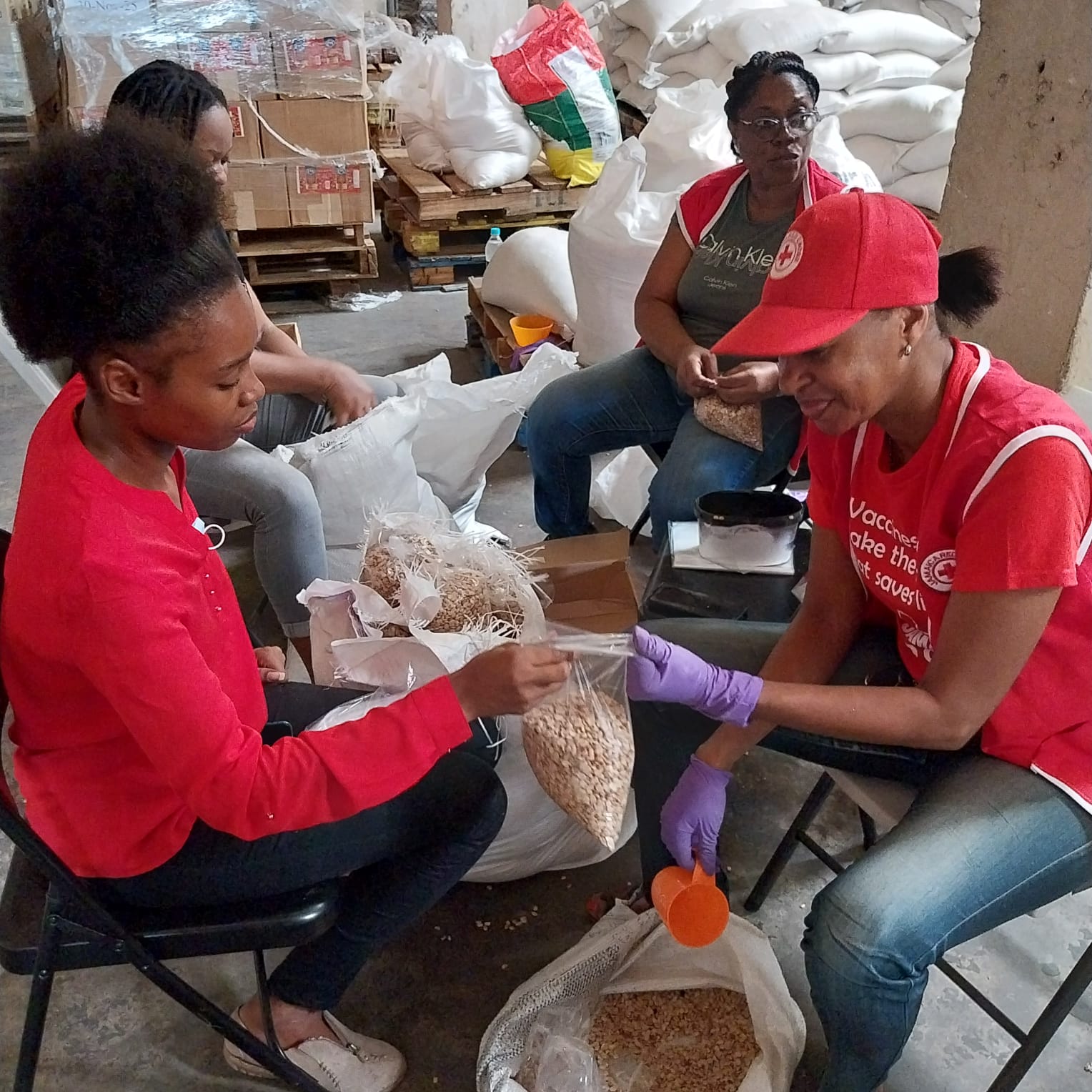
Jamaica Red Cross volunteers prepare relief supplies prior to Hurricane Beryl's landfall
Photo: Jamaica Red Cross Society
5. What should I do before, during and after a hurricane?
Before hurricane season begins, it is important to familiarise yourself with the risks in your area and develop an evacuation plan for your family and community. Identify the nearest shelters and map out safe routes. Make sure that everyone in your household knows what to do in an emergency.
To reinforce your home's structure, make sure the roof is securely fastened, install shutters, clean the gutters and trim any branches that could fall. You should also prepare supplies such as drinking water, non-perishable food, torches, medicines and a first-aid kit.
Once a hurricane warning or advisory has been issued, be prepared to evacuate if the local authorities instruct you to do so. Secure important documents in waterproof bags and place valuables in high places. Fill your car's petrol tank when it is half empty, in case you need to evacuate.
During the hurricane, stay informed through official media outlets and follow the authorities' instructions. If you are staying at home, reinforce your doors and windows and stay away from them. Seek shelter in an interior room without windows.
Bring pets inside, unplug small appliances and, if instructed, turn off the electricity, gas and water supplies.
Do not be fooled by the calm in the eye of the hurricane; stay safe until the authorities confirm that the danger has passed.
After the hurricane has passed, check for injuries and provide first aid, but do not move seriously injured people unless they are in danger.
Avoid damaged buildings and downed power lines, as these can cause electrocution. Do not consume water or food that may be contaminated and maintain good hygiene.
Support your neighbours and only participate in clean-up and recovery efforts when it is safe to do so. Stay informed about new alerts or secondary risks, such as flooding or landslides.